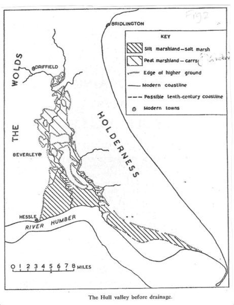
The above map is taken from the much referenced booklet published by the East Yorkshire Local History Society in 1958 and entitled ‘The Draining of the Hull Valley’, author June Sheppard. Incidentally, June Shepperd was no relation to Thomas Sheppard (1876-1945) the first curator of Hull Libraries; but she was an early student ay Hull University College Geography Dept. in the 1950s, after which she returned to London and worked in the Geography Dept. of Queen Mary College, East London for nearly 40 years.
The map shows that the whole of Kingston upon Hull developed across an area of estuarine silts, both east and west Hull up to Sutton. It is/was therefore extremely vulnerable to flooding both from the Waters of the Humber Estuary and from the waters of the lower course of the River Hull, a tidal river throughout its lower and middle reaches. So how could a settlement, however modest, have developed here in the Middle Ages? There is no doubt that the most employed solution (in part) was to excavate clay banks; that is a linear mound beside a trench from which the soil of the mound had been dug. The work would have been arduous given the equipment available and the workforce partly voluntary (paid by the day) or conscripted by one means or another. The end result would have seemed modest by today’s standards but effective except in stormy weather when wind waves would undermine the mound, in spring tides (on average two a month) or storm surges. Evidence for the building of clay banks in the past is hard to come by, the most valuable sources of evidence being Meaux Abbey Chronicles (up to the early 1400s) and Parliamentary Enclosure Awards (18th and early 19th centuries).
The other factor was a natural process by which channels which flood surrounding land gradually create a levee.
(to be continued)