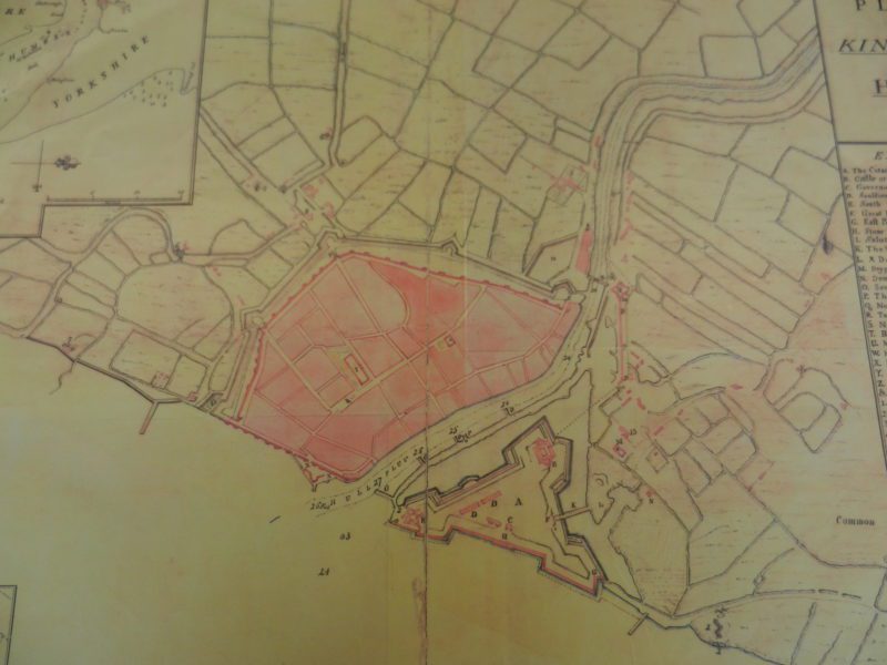
The above shows a plan of Hull dated 1725 which can be viewed in the Search Room of Hull History Centre. In the lower centre is the mouth of the River Hull ‘Hull Fluv.’ It is clear that even by 1725 the 14th century town walls remained intact and the massive Citadel dominated the east bank having all but obliterated the ancient hamlet of Drypool. The map shows the Citadel surrounded by a wide moat on three sides, the fourth alongside the Humber Estuary.
All the land shown on this map was hardly above sea level; very few areas are actually flat (a word often misused) but this area comes/came close.
It would be hard to argue that there are many communities which developed in a more precarious location than Kingston upon Hull. Not only would it have regularly received tidal water and silt in suspension from the Humber Estuary, but also tidal overflow from the lower course of the River Hull. How could a settlement have developed here? Well, certainly one did, at least in the 13th century, because King Edward I would not have granted a royal charter in the 1290s to an unpopulated area of estuarine marsh alone. That said, there is little or no evidence that it was a substantial settlement, probably, in my estimation, a modest outport for the more substantial port of Beverley.
Whatever the nature of that proto-port the risk of almost daily flooding must have been addressed in some form or other. Were there flood walls, clay banks or surrounding channels to take up the tidal waters? Certainly, the outport would have looked to the sea and river waters for its lively-hood, this with little access inland. Later in the 14th century great play was made of constructing causeway highways across the flood plain to the west and east. The word highway is a traditional term simply referring to a road surface of any sort and not necessarily a grand sort.
(to be continued).