Some years ago I was fortunate to be given a pack of papers and reports broadly relating to the Humber Estuary. One was a hard cover ‘Report on the Lighthouses, Lightships, Light Floats, Buoys and Vessels’ belonging to the Humber Conservancy Board, dated 1939.
The Humber Conservancy Board had been formed in 1908 at which point it inherited ownership of the Humber bed, this having been granted by the Crown Estate in 1868 (the ‘Crown’ normally owns the bed of estuaries and harbours). The Humber Conservancy Board was dissolved in 1966, and the British Transport Docks Board took over its responsibilities. The B.T.D.B. was, in turn, renamed Associated British Ports in 1981, this soon to become a private company, as today. Hull Trinity House had lost most of its responsibility for aids to navigation and pilotage in the Estuary in the 1850s when the predecessor to the Humber Conservancy Board had been formed.
Hence the Report on aids to navigation in the Humber Estuary in 1939.
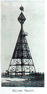
The aids to navigation described in the Report took various forms. The picture above is a scan of a photo of Kilnsea Beacon. This beacon, at the time of writing the Report, was already perilously near the rapidly eroded cliff top and did not last long after the Second World War. A beacon then was a tall structure of wood or metal on top of which were shapes (often a ball shape) which would be visible from out at sea/out in the Estuary. This particular beacon had two shapes at its top and pilots and sea captains would have reference sheets to different beacons or be familiar with them. This beacon was 84 feet in height and did not incorporate any lights, most later beacons did also have lights and mechanisms to generate the beams. Kilnsea beacon and Donna Nook beacon, this with a solid triangular top, denoted the extent of the mouth of the Humber Estuary.
(to be continued).