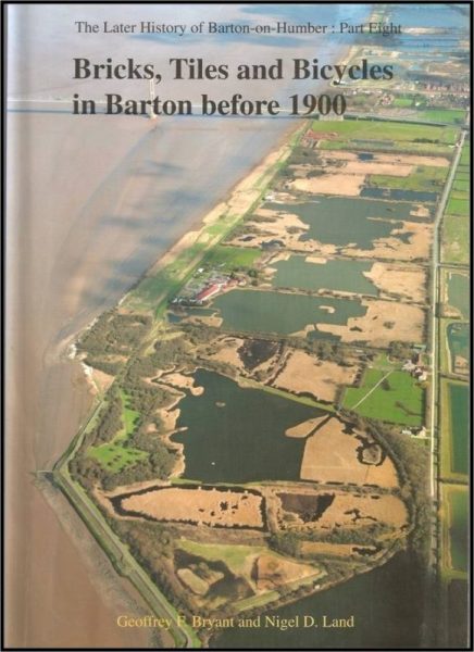
Beyond the end point of the Lincolnshire Marsh (s.p.b.) and beyond the neighbouring post-industrial site (s.p.b.) the ‘Marsh’ widens. The aerial photo shown above was reproduced on the cover of the book named and shows the next post-industrial area. This industry was directly connected to the drift geology of the ‘Marsh’ as the silt was dug as the raw material for making roof-tiles and bricks, the former could be made from the fine silts (most recently deposited) near the surface, the latter from the courser clay further down. By the late 19th century there were seven brickyards (factories) along the section of Humber foreshore shown above, hence the succession of lakes now. The Estuary-side location enabled the finished products to be transported by barges which would tie-up and the end of wooden jetties (bits of some remaining). The ‘claypits’ are now administered by the Linconshire Trust for Nature Conservation as wetland nature reserves and the whole are is popular with ornithologists.
Just off-screen at the top is the mouth of Barton Haven, a tidal inlet that crosses the ‘Marsh’, east of the Haven is the next section of the Marsh as one moves towards the parish of Barrow on Humber. Here are a succession of further lakes where clay was once dug albeit mostly products of the 20th century industry. As well as information boards dotted along the Humber bank an information leaflet has recently been published for this stretch of the Marsh focussing on its industrial history as well as its Nature conservation value.
As in Barton (before industrialisation) the Marsh in Barrow, before Parliamentary Enclosure in the late 18th century, had been the common land of the parish. Here the Marsh is crossed by Barrow Haven, a chalk spring fed stream.
Moving further east past the port of New Holland, with its pre-Humber Bridge jetty still in place, brings us to the expansive flat-land of Goxhill ‘Marsh’.
(to be continued).