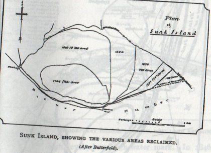
Today’s illustration is again taken from Sheppard, T. The Lost Towns of the Yorkshire Coast, (p. 45, 1912) (my copy is a reprint) and shows the successions of land reclaimed from the Humber mudflats along the north bank of the Humber Estuary (south coastline of Holderness), this is the land that came went and came again. As stated in the previous blog a large part of this area had, by the 14th century, been reclaimed by a succession of clay banks (modest in size by today’s standards) and given over to grazing land for sheep. Although technically claimed by the Crown this new land was administered by Cistercian monks from Meaux Abbey, sited in the marshes of the Hull valley east of Beverley. Annual supplies of wool was then the basis of national wealth and Cistercian abbots and monks were hard working, allocating much time in the day for non ceremonial activities, and capitalist minded.
Presumably the monks would either travel overland on foot between the Abbey site and south Holderness or, more likely, travel by boat down the River Hull and out into the Humber before landing at a purpose-built jetty. Once there, they would act as shepherds based at granges (or hostels) on the reclaimed land.
The ‘Lost Towns of the Humber’ as identified by J.R. Boyle, s.p.b., were: Tharlsthorp, Frismersk, East Somert, Penisthorpe, Orwithfleet, Sunthorp and Ravenser Odd. Despite the previous reservation about ‘towns’, s.p.b., this seems like a lot of settlements on such a precarious environment. But to return to the question ‘where did this information come from? after all it is related to the area over 700 years ago. The answer is that apart from occasional mentions in State Papers the information mostly comes from the Meaux Chronicles, compiled by retired abbot around 1400 and really recounting the history of the monastery and its lands from the 12th century to the beginning of the 15th century. These were translated from the latin by the Rolls Society in the late 19th century, and copies can now be read at Hull History Centre. This evidence of settlement on the mudflats of south Holderness was therefore written much nearer to the time when they did/may have existed.
However, Abbot Burton could never have seen any of these, just heard or read about them. Why so? Because national studies show that by the late 13th century sea levels were rising gradually across north-west Europe and, although not as dramatically as today, nevertheless sufficient to sweep away flimsy clay banks of areas at sea level, especially at spring tides. There are many extracts from the Meaux Abbey Chronicles that refer to land lost to flooding, buildings lost to flooding and sheep being drowned in the first half of the 14th century. The most documented settlement to be lost to flooding at this time was Ravenser Odd which was by 1300 a significant port near the mouth of the Humber, which had a church, domestic buildings as well as warehouses and was frequented by many sailing ships. By 1360 all were lost to the sea, the commercial centre that came and went.
So then this is the region off the south Holderness coast which came and went.
But how, when and why did it come again?
(to be continued).