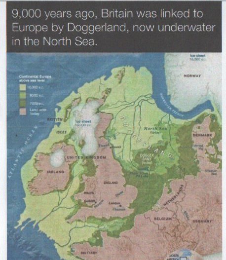
The above map is copied from the Doggerland Facebook page. It sets out to show that between 20,000 and 9,000 years ago the North Sea, English Channel and Irish Sea were above sea level with successive series of natural vegetation and fauna, including Neandertal Man and, possibly Palaeolithic Homo Sapiens. The explanation lies in the ebb and flow of periods of glaciation followed by inter-glacial episodes of climate change. As the climate of the Northern Hemisphere cooled sea levels around the Planet went down as so much water was transformed to ice, this in turn creating vast masses of compacted ice that then began to move, whether following underlying landforms or driven on by the largest ice masses.
In the case shown above current sea levels were much lower, so-much-so that the now bed of the North Sea was then above sea level. Geologically such episodes were short lived, nevertheless time for flora and fauna to develop on the land. These adaptations would in turn be relatively short lived because as the polar ice masses built up so there would be a succession of flora and fauna each better adapted to the changing climate. Woolly mammoths are often cited as adapting fauna as in modern times it has not been too uncommon for mammoth tusks to be caught in fishing nets and brought ashore.
Similarly, as the post-glacial climate warmed so global sea levels rose an d sea water encroached across low lying plains such as now the bed of the North Sea. The term Doggerland is used to refer to this low lying plain. Dogger Bank, once rich fishing grounds and now the site of many offshore wind turbines, was an area of low hills in Doggerland. Given the gradual encroachment of a rising sea level these must have been offshore islands for a brief while, the last reserve of the mammoths maybe.
Another object sometimes hauled up from the bed of the North Sea by trawlers were ‘erratics’, large boulders not matching the geology in which they now sit but which were plucked from their home area by glacial movement and deposited randomly as the Ice Age retreated. These were occasionally donated to municipal parks in their early days as objects of interest. A number survive, in Oak Road Playing Fields for example, but are no longer labelled.
The colour scheme on the map above shows how the sea encroached across the lowland plain over time and in the wake of the retreat of the last ice age.
(to be continued).