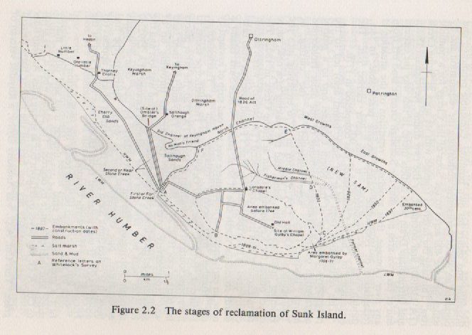
The map on p. 25 of Jones, N.V. A Dynamic Estuary: Man, Nature and the Humber (Hull University Press, 1988) shows the stages by which mudflats around Sunk Island were ‘reclaimed’ between the 1760s and 1897. The process by which this was done was exactly the same as that employed by the Medieval Cistercian monks based at Meaux; a linear embankment and ditch dug at low tide and strengthened at successive low tides. Doubtless the monks would have required a larger workforce than they themselves could provide so would have let it be known that day labourers were needed, probably at an attractive day rate of pay. Certainly, again in the 19th century there is evidence of day labourers attracted to the area by the same incentive, particularly Irish.
This 19th century reclamation spread out from Sunk Island itself, although tidal strength south of the Island limited what could be done. Most of the land so reclaimed was north of the Island (between it the settlements of south-Holderness), eastwards to Patrington Haven and north-west across Cherry Cob Sands south of Paull.
Of course the grazing land overseen by the 14th century Cistercian monks and the ‘lost settlements’ did not cover an area as extensive as the reclaimed land we see today, but must have been the northern section shown on the map above. It is not clear whether Sunk Island existed in the Humber back in the 14th century, possibly not as I don’t recall a mention in the Meaux Abbey Chronicles (although I could be wrong here).
So walking south from Camerton, Keyingham or Ottringham past the arable fields of today one could be thinking that here is land that was, which went and which has come again.