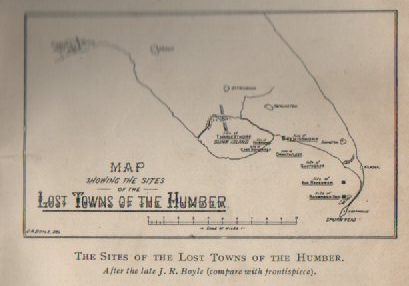
Today’s image is from page 49 of Sheppard, T. ‘The Lost Towns of the Yorkshire Coast’, (London, 1912), a misleading title as be is concerned with those of the Holderness coast, lost over tome as a result of coastal erosion. The north bank of the Humber Estuary is part of the Yorkshire coastline (although strictly speaking today it is the coastline of two unitary authorities and part of it was once Hullshire’s coastline) but for the purpose of the above map Sheppard was copying a map from Boyle’s publication on the lost towns of the Humber. The word towns is not to be taken literally, it is used here as a generic word for any settlement. Mr. Boyle was Hull Corporation’s first salaried archivist and he was roughly a contemporary of Thomas Sheppard.
The essential point about the above map is that the shoreline of the north bank of the Humber may have been somewhat similar to that of today, and that this natural accumulation of estuarine silt along the shoreline had become vegetated and habitable, this happening from Anglo-Saxon to early medieval centuries. However, for whatever reasons, this natural accumulation began to be eroded by changing currents in the Estuary and thus the settlements shown above were ‘lost’. However again, from the 18th century estuarine muds were again made habitable by natural accumulation and Man’s intervention. No physical evidence of these lost ‘towns’ of the Humber survived in the reclaimed landscape.
So where did Boyle and Shepperd get the evidence to prove/suggest that these ‘lost towns’ ever existed?
(to be continued)