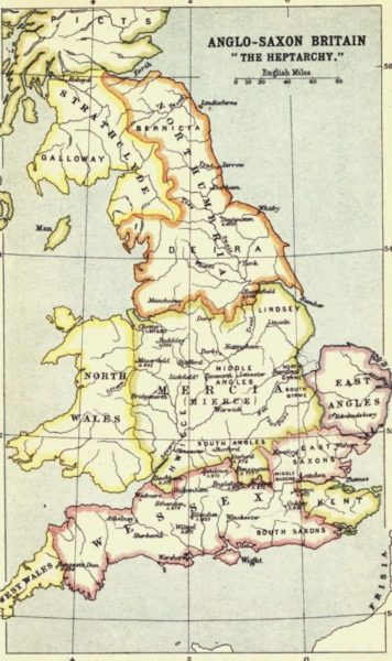
The map above shows the seven Anglo-Saxon kingdoms existing in England before Danish (Viking) settlement and the creation of the Danelaw, 8th century for example. As can be seen, the Humber Estuary formed a boundary between Deira, the southern region of the Kingdom of Northumbria and Lindsay, the northern region of the Kingdom of Mercia and independent for a short while. Nevertheless, the Estuary would have been trading highway and the ferry from Barton to Hessle may already have existed, it certainly did by 1086.
So how was Hull doing as a port at this time? The probably answer is that it wasn’t. Remembering that an Anglo-Saxon port would have been little like a modern port, the two certain ports on the Humber at that time were Beverley and Barton; both in their early days as Barton was a planned grid-plan Anglo-Saxon settlement and Beverley was an ecclesiastical settlement although served by the navigable River Hull by which it was connected to the Humber Estuary. By the 11th century both Barton and Beverley were served by a tidal canalised watercourse. Hedon was to follow in the 12th century as a planned trading settlement funded by the Lords of Holderness and connected to the Estuary by a canalised watercourse.
If any settlement existed at Hull, more correctly Myton, at that time it had a more precarious site than the others but potentially more lucrative.
I would suggest that in the Saxo-Norman 11th century what existed in the Myton area was probably buildings related to the site being an outport to the trade of Beverley and supervised by the merchants of Beverley. What it looked like and how big, or not, it was is a matter of speculation.
(to be continued).