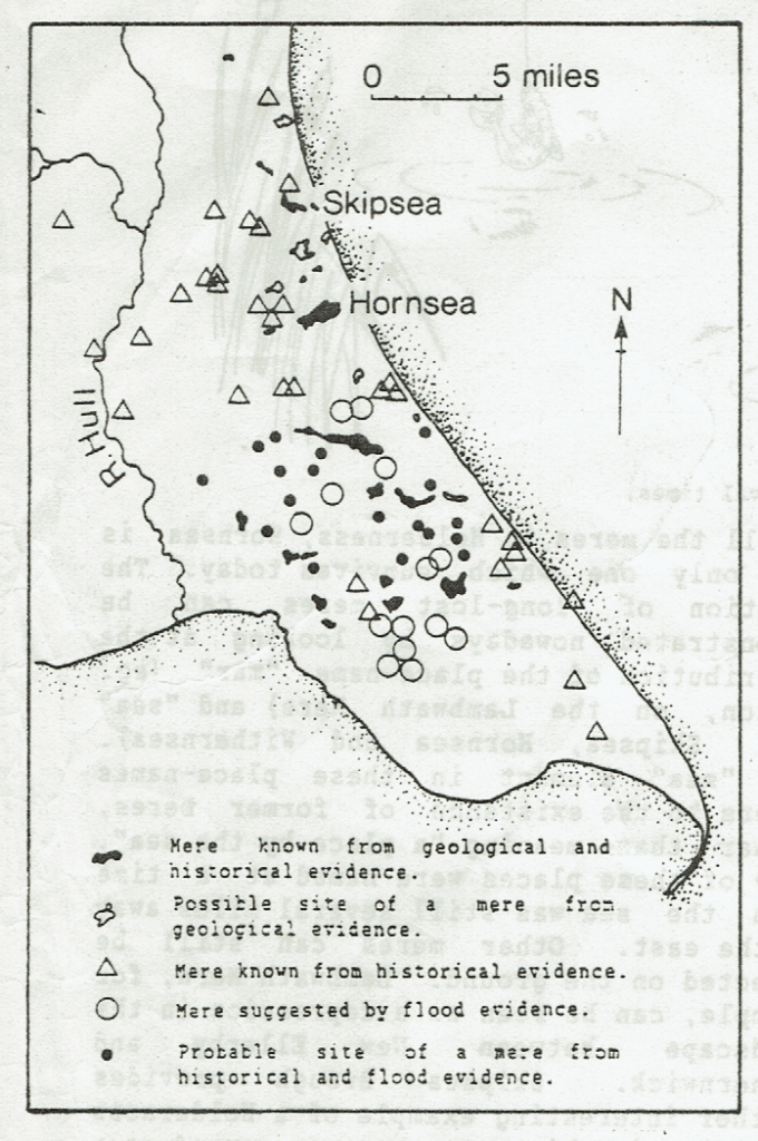
In 1988 Humberside County Council Archaeology Unit published a Bulletin summarising their North Holderness Survey. To continue this section of my study I will precis their information before going on to precis the final chapter in Professor English’s book ‘The Lords of Holderness 1086 – 1260’. Inevitably the four unitary authorities that replaced Humberside County Council have been comparitively poor at funding historical research and so it’s often worth checking-out work done prior to 1996.
The map above is copied from the Bulletin. As all the symbols relate to a definite, or possible, site of meres it gives a clear impression of this aspect of the Holderness landscape in late pre-historic times. The low density of meres in South Holderness is partly explained by the fact that the map does not show the pre-historic coastline of South Holderness (before the reclamation of Cherry Cobb Sands and Sunk Island).
The Bulletin was compiled from the studies of the North Holderness Field Survey Team based (then) in Hornsea. It then mentions the phrase ‘lakes and meres’ which raises the question, what is the difference? I guess Hornsea mere could well be called a lake but it is very shallow, maybe then this is key to the difference.
The Bulletin then goes on to make the point (made here in previous blogs way back) that there may have been a succession of Holdernesses during inter-glacial periods when the climate warmed to higher average temperatures than today, to reinforce this point the Team reference fossils of ‘bison, rhinocerous, elephants and lions’ unearthed. Another question, posed in a previous blog, is whether some lower clay strata exposed along the coast dates from before the last glaciation and was not bulldozed away during the last ice age.
With the post-glacial warming of the climate the colonisation of flora and fauna change, comparatively rapidly, over time.
(to be continued).